Welcome to Teaching Students with Visual Impairments |
Social Studies AdaptationsBy: Carmen Willings
teachingvisuallyimpaired.com Updated May 25, 2024 Collaboration between classroom teachers and Teachers of the Visually Impaired (TVIs) is essential for ensuring that students who are blind or visually impaired can fully access and participate in social studies instruction. The following strategies and considerations can be helpful.
Adaptations in MaterialsTables and Charts
Classroom VisitorsIf it is not possible for your class to go off campus, consider inviting a guest speaker/visitor to talk about their job and bring objects for the students to explore. Invite a guest related to the unit to come in and discuss information related to the topic and provide hands-on experiences for students. Encourage students to listen attentively to the speaker. Encourage students to use active listening skills. Encourage students to relate what they heard with prior knowledge.
Accessible Social Studies Materials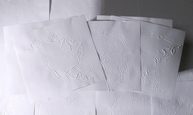
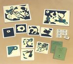
Braille Transcribers Kit: Countries and Continents from APH, is a collection of embossed and printed outlines of maps commonly found in history, geography, and social studies textbooks. The embossed sheets can be used as templates when you create tactile maps. Features can be added using tactual graphics tools, craft ink, textures, and braille labels. They can also be used as masters for swell paper tactile graphics. APH recommends making a photocopy of images onto capsule paper, add labels, lines, and symbols, and produce the raised image by running the graphic through the heating machine.
Braille Transcriber's Kit: U.S. Maps from APH, is a collection of embossed and printed drawings of figures commonly found in history, geography, and social studies textbooks. Maps include North America, including Canada, the United States, and Mexico, the U.S. outline, U.S. with 50 states outlined, Western region states, Eastern region states, and the original 13 colonies. The embossed sheets may be used as templates for thermoforming. APH recommends making a photocopy of images onto capsule paper, add labels, lines, and symbols, and produce the raised image by running the graphic through the heating machine.
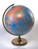
Globe: Tactile and Visual This table model from APH is a standard 12" political globe covered with a tactile clear plastic overlay. Among the overlay's features are continent outlines, higher and lower elevations, and raised latitude and longitude lines.
Map Study I Kit: Maps Represent Real Places. This kit from APH introduces basic map concepts by having students map a classroom and other known environments. Students learn to find objects and to identify map symbols representing those objects.
Recognizing Landforms: An Audio-Tutorial Program in Map Study . This program from APH uses characters on cassette tape to introduce 40 geographical concepts, such as distinguishing mountains from valleys, channels from bays, etc. It includes 10 tactile landforms and cassette tapes.
This relief map, available from APH, of the continental U.S. with elevations that are exaggerated 20 times. Ocean floors are incised with latitude and longitude lines. This plasticmap uses high-contrast paint to depict water areas as blue and land surfaces as yellow and brown.
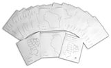
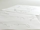
This State Map Collection from APH is a set of embossed and printed outline maps for a region of the United States. APH recommends adding to the images with tracing wheel lines, craft ink, glued-on textures, etc. Braille labels can also be added.
Tactile Town: 3-D O&M Kit Although this kit, available from APH, is designed to be used to teach O&M skills, it is also a great tool to use when teaching local geography units such as neighborhoods and towns.
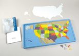
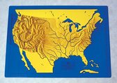
U.S. Puzzle Map This large, colorful, and tactual map from APH is topographical. It features tactile mountains, rivers, and state capitals. State abbreviations in braille as well as latitude and longitude lines. It also includes masking overlays for assessment purposes.
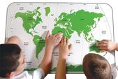
World at Your Fingers . This set of tactile world maps, available from APH, features a large tactile reference map showing the major oceans and land masses of the Earth using high-contrast raised surfaces, braille and print labels, and textured lines and areas.
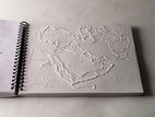
World Maps. These thermo-formed tactile maps from APH are a comprehensive aid to geographic instruction and orientation. The tactile maps include all the continents, regions, and countries of the world. They differ from other tactile maps in that they use clear variations in height and texture, allowing a greater amount of readable information in a given space.
|
ECC Instruction
Concept Development
Alternative Communication
Tactile Graphics
Access Classes
VI AT Printables Webinar: Selecting the Right AT Overview of Assistive Technology Basic AT Use Problem Solve AT Braille Notetaker Use iOS/Tablet Use
Basic Computer Use Computer Access Windows Keystrokes Word Processing & Shortcut Productivity Online Access VI AT Resources Sensory Input Sensory Areas & Rooms Routines Auditory Readiness Visual Efficiency Skills
Responsibility & Independence General Home Safety Bathroom Adaptations Personal care Hygiene & Grooming Personal Health Medication Adaptations Household Skills Maintenance Shopping & Consumerism Dressing & Clothing Identification Clothing Care Telephone Use Eating & Table Manners Food Preparation Service Agencies Safety Money & Budget Eating & Table Manners
|
|
Teaching Students with Visual Impairments LLC
All Rights Reserved 
|